
Reclassification/Redefinition Lake Tashmoo V8.2
Ladies and Gentlemen:
In accordance with Chapter 130, Section 74A of the Massachusetts General Laws, the Division of Marine Fisheries has determined that the below-defined “CONDITIONALLY APPROVED” shellfish growing area in Lake Tashmoo (V8.2), in the Town of Tisbury, no longer meets the established criteria for the harvest of shellfish due to seasonal water quality changes and the NSSP Mooring Area criteria. The status of this area will be changed to “CLOSED TO SHELLFISHING” as of sunrise on May 15, 2023.
Therefore, under authority of Massachusetts General Laws, Chapter 130, Section 74A, the status of the below-defined area has been changed to "CLOSED TO SHELLFISHING" to the taking of all shellfish. Digging, harvesting or collecting and/or attempting to dig, harvest or collect shellfish and the possession of shellfish from the below-defined area is prohibited. Under authority of 322 CMR 7.01(7) all permits issued thereunder are hereby conditioned to prohibit the taking, selling or possession of shellfish from the below-defined area.
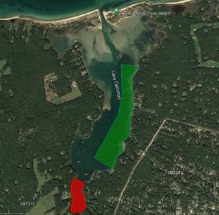
CLASSIFICATION: CONDITIONALLY APPROVED SEASONAL STATUS CHANGE Status: Closed to Shellfishing May 15 - October 31 All Dates Inclusive V8.2 East Tashmoo Mooring Area “The waters, flats and all tributaries of Lake Tashmoo south of a line drawn west from the “NO SHELLFISHING” sign on the shore at the end of Tashmoo Wood to the Town buoy at the northwestern corner of the mooring field, east of a line drawn thence south along Town buoys located east of the mooring field off Hvoslef Way and the end of Serusa Lane, and continuing due south to the Town Buoy located at the southwestern corner of the mooring field, and north of a line drawn thence to the base of the dock at 68 Bishops Cove Way”.